Skip to content
Earth Imaging: Signals & Algorithms

Earth Imaging: Signals & Algorithms

Tolulope Olugboji (Principal Investigator)

Menu

  • Home
  • Research @ URseismo
    • Publications
    • Projects @ URSeismo
    • Recorded Talks
      • Past (Map)
    • Software
    • Open Data
  • People
    • Current Members
    • Interns/Alumni
    • Collaborators
  • Outreach & Education
    • Educational Outreach
      • NSF Eager (Lightboard Lectures)
    • Courses (Rochester)
    • Teaching Philosophy
    • Resume
  • News/Press
  • Contact
Launch YoUR Career @UR

Launch YoUR Career @UR

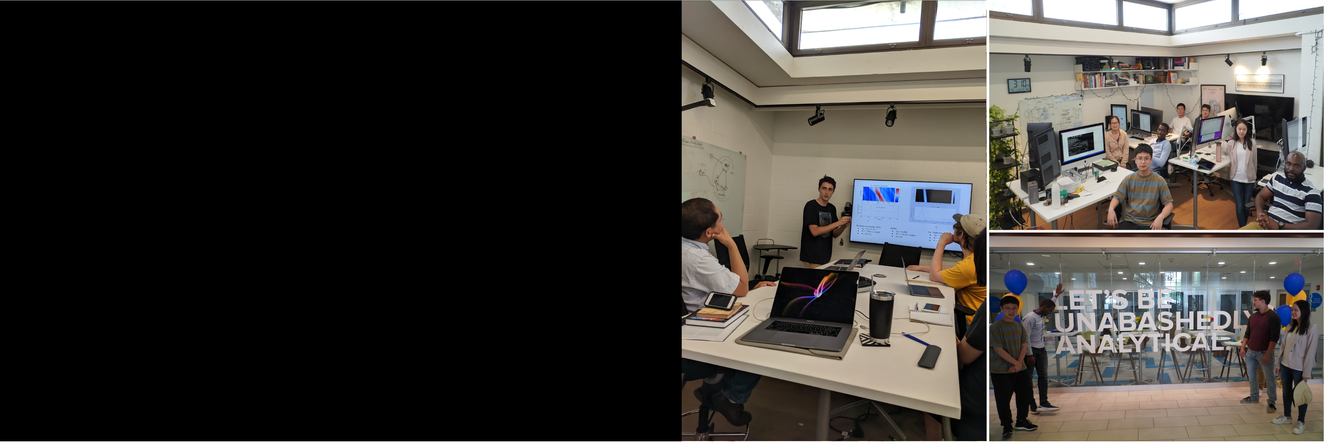
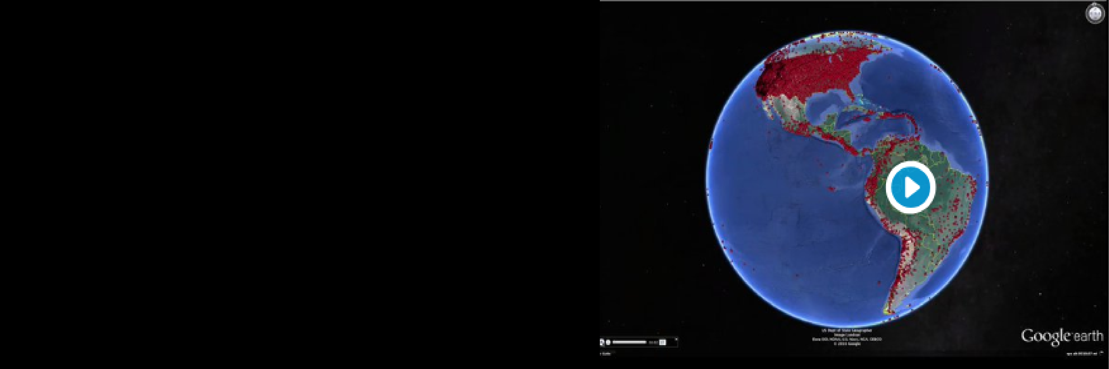
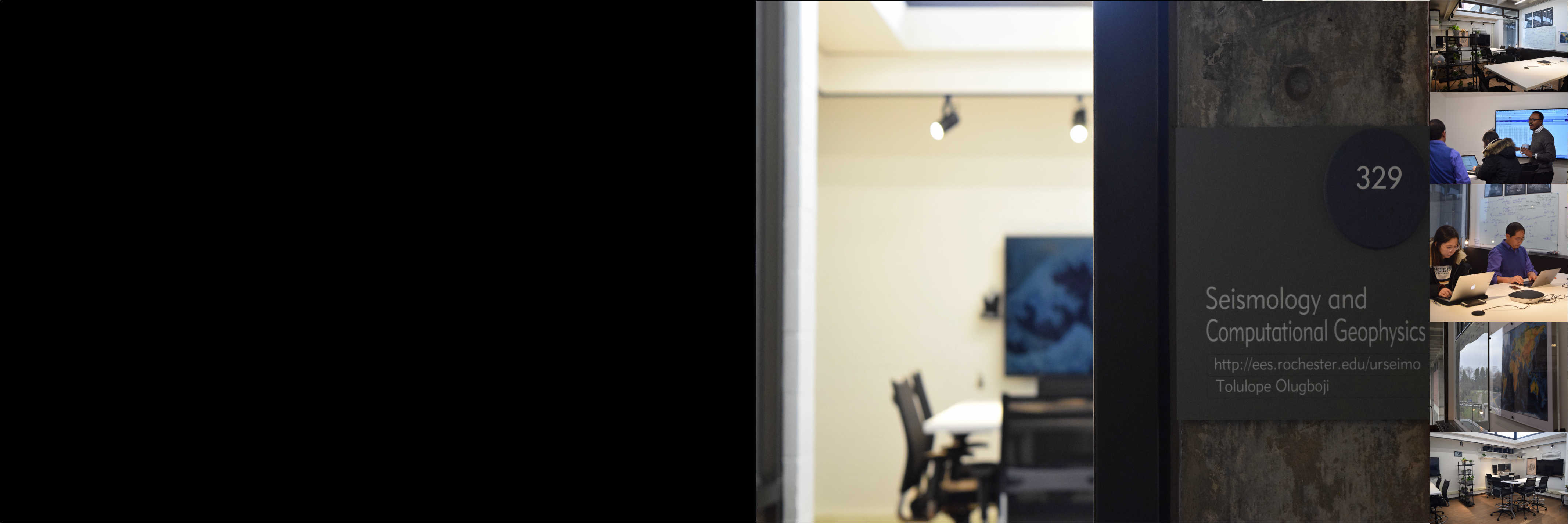
The Olugboji Earth imaging lab uses our planet’s vibrations to understand its internal anatomy and trace its dynamic history. This involves conducting planetary imaging using novel algorithms that enable Earth exploration. Our group comprises earth scientists, electrical engineers, computer and data scientists. Our research spans the entire globe and out to Mars. To discuss research interests please come up with creative ideas that overlap with current research themes before scheduling a meeting.

Projects @ URSeismo
Earth Imaging with Ground Vibration

Earth Imaging with Ground Vibration

Our research integrates innovative algorithms and large datasets, leveraging high-performance computing. We focus on: Global ocean structure, crust and mantle imaging, probabilistic deconvolution, Earth imaging with AI, Mars crustal structure, global Earth modeling with large arrays, noise monitoring, signal reconstruction, stress modeling with earthquakes, and machine learning on vast datasets. These efforts advance Earth system science, offering new insights into terrestrial and planetary structures.

Research @ URSeismo
Learn about our Dynamic Planet

Learn about our Dynamic Planet

Our courses equip students with the knowledge and skills to tackle pressing global challenges. Earth imaging and remote sensing uncover the planet's details and reveal natural hazards like severe weather, landslides, and tsunamis. Topics such as signal estimation and earthquake detection enhance early warning systems. Enroll in Nature’s Fury, Data Analysis, Earth Imaging, and Signal Processing, available for all levels. Check our listings for available courses today!

Courses @ URSeismo
We are Open for Science

We are Open for Science

Our people, space, and collaborative culture drive innovation in science! We are Open for Science with a modern computing lab featuring teleconference capabilities, dedicated spaces for research and software development, and multi-core, dual-display iMacs. Leverage advanced high-performance computing with GPUs and hundreds of compute cores. Navigate to the ‘people’ section to learn about our team and their current projects. Join us in advancing scientific exploration!

Facilities @ URSeismo

From Oceans to Africa: Students Present Breakthroughs at AGU and Celebrate with Alumni

From Oceans to Africa: Students Present Breakthroughs at AGU and Celebrate with Alumni
Tolulop Olugboji December 13, 2024December 13, 2024 Uncategorized No Comments Read more

Preprint: N-America’s Mid-mantle Reflectivity with CRISP-RF

Preprint: N-America’s Mid-mantle Reflectivity with CRISP-RF

Follow preprint link to new paper by  Carr, Steve, Tolulope Olugboji, Jeffrey Park, and Shun-ichiro Karato. “High-resolution Mapping of North America’s Mid-Mantle Reflectivity provides Evidence for Dehydration Melting.” (2024). [https://essopenarchive.org/doi/full/10.22541/au.172306264.48579962]

Tolulop Olugboji August 13, 2024August 13, 2024 Uncategorized No Comments Read more

New Summer Interns Onboarded

New Summer Interns Onboarded

We are excited to have four new summer interns join us this summer. See details here: https://www.sas.rochester.edu/ees/urseismo/current-members/

Tolulop Olugboji May 3, 2024May 6, 2024 Uncategorized No Comments Read more

Joel to attend Nemmers workshop @ NorthWestern Univ

Joel to attend Nemmers workshop @ NorthWestern Univ

Jean-Joel Legre was recently admitted to attend the Nemmers workshop at Northwestern from May 20-24. The conference will gather scientists involved in research on Volcano and Rift Seismicity in Africa

Ziqi Zhang April 4, 2024May 3, 2024 Uncategorized No Comments Read more

Group Attends Imaging Workshop in Cargese, France

Group Attends Imaging Workshop in Cargese, France

Dr. O, Jean-Joel Legre, and Steve Carr were invited to attend Seismological Workshop on “Passive imaging and monitoring in wave physics: from seismology to ultrasound“ at the Institut d’Etudes Scientifiques de Cargese, France, from June 3-7, 2024.

Ziqi Zhang April 4, 2024May 3, 2024 Uncategorized No Comments Read more

Sayan (Data Scientist) Joins Team as Research Assistant

Sayan (Data Scientist) Joins Team as Research Assistant

Sayan is joining the team to assist with different deep learning and data science projects

Tolulop Olugboji January 23, 2024February 23, 2024 Uncategorized No Comments Read more

Paper Alert: Africa’s Crust Imaged with Machine Learning

Paper Alert: Africa’s Crust Imaged with Machine Learning

Read paper on Tolulope Olugboji, Siyu Xue*, Yuri Tamama*, Jean-Joel Legre** . Africa’s Crustal Architecture Inferred from Probabilistic and Perturbational Inversion of Ambient Noise: ADAMA, in press Gcubed, https://doi.org/10.1029/2023GC011086, [pdf]

Tolulop Olugboji January 16, 2024February 23, 2024 Uncategorized No Comments Read more

Preprint Alert: Taxonomy of Upper Mantle Layering in US

Preprint Alert: Taxonomy of Upper Mantle Layering in US

Read preprint submitted to JGR here: Steve Carr** and Tolulope Olugboji. A Taxonomy of Upper Mantle Stratification in the US, in review at AGU-Advances. (DOI: 10.22541/essoar.170533935.54641104/v1)

Tolulop Olugboji January 15, 2024May 3, 2024 Uncategorized No Comments Read more

Grant Alert: Joel wins SSA Travel Grant (Twice)

Grant Alert: Joel wins SSA Travel Grant (Twice)

Second time in a row (2023 and 2024) See news here: https://www.seismosoc.org/awards/travel-grant-types/past-annual-meeting-travel-grant-recipients/

Tolulop Olugboji January 12, 2024February 23, 2024 Uncategorized No Comments Read more

PhD Paper Alert: Crust Imaging with Noisy Data (CRSIP-RF)

PhD Paper Alert: Crust Imaging with Noisy Data (CRSIP-RF)

Read paper by: Ziqi Zhang** and Tolulope Olugboji. Crustal Imaging with Noisy Receiver Functions, BSSA, https://doi.org/10.1785/0120230254. [preprint-pdf].

Tolulop Olugboji January 8, 2024February 23, 2024 Uncategorized No Comments Read more
  • « Previous
  • Next »

OlugbojiLab @AGUNewOrleans

weeks
0
2
days
0
2
hours
2
0
minutes
1
9
seconds
5
3

Upcoming Events

@AIRdGrp | @RdGrp | @GrpMtg

Seismic Network

S1: Hutchison Hall Basement
S2: Webster, Lake Ontario

Google Maps Multiple Markers

Recent Posts

  • Lab Alumna Siyu Xue Publishes AkiNet in JGR: ML
  • Celebrating Dr. Carr: Unlocking Secrets of Continental Mantle
  • From Oxford to Gordon: PI Delivers Global Research Highlights
  • AfricaArray 2026: Bridging Tectonics and Societal Needs
  • Legre’s Deep Dive: Unraveling the Origins of Africa’s Mantle

Recent Comments

    Featured Downloads

    • Introduction to Seismology (64879 downloads )
    • UR Onboarding (392796 downloads )

    Categories

    • Uncategorized

    Contact Information

    Follow Link to Schedule A Meeting Rochester | NY | USA Office: Hutchison 224B Lab: Hutchison 329 Phone: (585) 3276-6609 Fax: (585) 244 5689 Email: tolulope dot olugboji at rochester dot edu Lab: UR Seismology Laboratory Site: ees.rocheseter.edu/urseismo

    News/Press

    • Lab Alumna Siyu Xue Publishes AkiNet in JGR: ML
    • Celebrating Dr. Carr: Unlocking Secrets of Continental Mantle
    • From Oxford to Gordon: PI Delivers Global Research Highlights
    • AfricaArray 2026: Bridging Tectonics and Societal Needs
    • Legre’s Deep Dive: Unraveling the Origins of Africa’s Mantle

    RSS USGS: Big Quakes Past Month

    • M 6.0 - 12 km WNW of Susitna, Alaska
    • M 4.0 - 8 km E of Gilroy, CA
    • M 6.6 - 45 km WNW of Sinabang, Indonesia
    • M 4.9 - 10 km NW of Beluga, Alaska
    • M 4.1 - 7 km W of Templeton, CA
    • M 5.4 - 48 km ESE of Fox River, Alaska
    • M 5.4 - 14 km SSW of Narsingdi, Bangladesh
    • M 6.2 - 29 km SE of Mazār-e Sharīf, Afghanistan
    • M 3.8 - 3 km SE of San Ramon, CA
    • M 3.5 - 4 km SSW of Vallejo, CA

    RSS Earthscience News

    • Major droughts linked to ancient Indus Valley Civilization's collapse
    • Satellites spot surprising tsunami patterns: Massive Kamchatka quake challenges old models
    • Researchers develop novel bathymetric framework for high-accuracy shallow-water mapping
    • Avalanches are of key importance to glaciers worldwide
    Copyright © 2025 Earth Imaging: Signals & Algorithms. All rights reserved. Theme Spacious by ThemeGrill. Powered by: WordPress.